Updating Magnetic Declination in MSFS-2020

Sometimes, the aircraft during an approach does not correctly align with the runway heading published on the approach chart. This can lead to a RW/APP CRS Error to be displayed on the FMA.

Before exploring scenery, navigational database and add-on inconsistencies, the problem may be that the magnetic declination in flight simulator is not correct for the runway or scenery being used.

The magnetic declination forms part of the database table that relates to any scenery (and airport runway) used in flight simulator.

I have written about magnetic declination in two earlier articles, however, these articles related to FS9 and FSX and not MSFS-2020.

Magnetic Declination

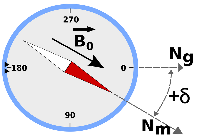
Simply explained, magnetic north is the direction that the north end of a compass needle points, which corresponds to the direction of the Earth's magnetic field. True north is the direction along a meridian towards the geographic North Pole. The magnetic declination (also called magnetic variation) is the angle measured between true north and magnetic north.  This distance changes annually and is one of the reasons that a topographic map has a declination table printed in the margin. Without a declination table, the map would soon become inaccurate.  To calculate the magnetic declination the map user, depending upon their position, would add or subtract the declination from the bearing to obtain an accurate bearing to plot a course.

Flight Simulator

The magnetic declination used by flight simulator is stored in a .bgl file named magdec.bgl. This file is usually located in the simulator’s scenery database.  The file is accurate at the time of development, but if not updated regularly will be incorrect for today’s date.

You would expect magnetic declination errors with flight simulator platforms such as FS9, FSX and earlier versions of P3d; after all, they were released several years ago, but deviation errors are also seen in MSFS-2020.  The reason for this is that Microsoft did not compile a new magnetic declination table when the scenery was developed; rather, they used the existing table from FSX.  The exception being for some of Asobo’s airports which probably do have up-to-date declination.  

Considering that MSFS-2020 is automatically updated, it would have been a relatively easy task to also update the magnetic declination (perhaps in the future).

Updating Magnetic Declination

Updating the declination for MSFS-2020 involves replacing the magdec.bgl file with an updated file.

This file can be downloaded free of charge from Herve Sor’s website (the .bgl file is regularly rewritten to reflect declination changes).  Be sure to read the accompanying Read Me file for further information.

Locating the .bgl file (MSFS-2020)

The magdec.bgl file is located in the following directory: 

  • C:\Users\LOGINNAME\AppData\Local\Packages\Microsoft.FlightSimulator_8wekyb3d8bbwe\ LocalCache\Packages\Official\OneStore\FS-base\Scenery\Base\Scenery

Note that if you have done a custom install of MSFS-2020 to a different drive, then the folder structure should represent the location you have installed the software.

If using Steam, the folder structure is:

  • C:\Steam\Steamapps\Common\MicrosoftFlightSimulator\Official\OneStore\fs-base\Scenery\Base\Scenery\

Installing the .bgl file

Find and open the scenery folder.  Prior to changing anything, always make a backup of the existing magdec.bgl file.  Be sure to remove the .bgl file extension.  I would suggest renaming the file to magdec_backup_original.  This enables you, if necessary, to easily roll back the file (after changing the file name back to the original name).  The backup file can either remain in the folder or be removed to another location for safe keeping.  Next, copy and paste the new magdec.bgl file to the folder.  When you open flight simulator the magnetic declination table will be rebuilt during the start-up process. This may take a few minutes.

Important Point:

  • After downloading the zip file from Herve’s website, open and read the Read Me file which provides additional information.

Other Simulator Platforms

To update the magnetic declination for other simulation platforms, ensure you download the correct updated magdec.bgl file for the simulator being used.  The installation route is usually the Scenery/Base/Scenery folder.

Magnetic declination is important. The declination information for the approach chart and the simulator must be identical (Aero Icarus from Zürich, Switzerland, Runway of Funchal airport, July 11, 2011 (5939970718), CC BY-SA 2.0)

Do I Need To Update ?

The flight simulator can only reproduce accurate navigation based on the quality of the installed database. If you are using Navigraph data and your simulator’s declination is not correct, a corresponding error will occur between Navigraph and the scenery in the simulator.

If you use an approach chart, the magnetic declination record between the chart and the simulator must be identical; otherwise, the approach course will be inaccurate (landing left or right of runway).  Likewise, if you are using Lateral and Vertical Navigation (LNAV and VNAV) and have the incorrect declination, the aircraft will not fly the correct course during an automated approach (for example an RNAV approach).

The update is a very simple process and takes but a few minutes and it is strongly recommended.

Final Call

Magnetic declination is a critical factor to consider, before investigating other potential causes for navigational discrepancies. To ensure accurate navigation ensure the magdec.bgl file is up-to-date.

Glossary

  • FMA - Flight Mode Annunciator.

Magnetic Declination and Navigation Database Update

There's little point using real aircraft parts (OEM) when the underlying databases in flight simulator, that provide aeronautical information, are out-of-date.  A commonly encountered problem is: 'Why is the approach course on the simulator different to that published in the approach chart'

If wanting to achieve a high degree of realism when flying flight simulator, then up-to-date aeronautical information is vital. 

Navigraph strives to maintain the accuracy of their charts and database sets by releasing quarterly updates.  However, up-to-date data is pointless if the baseline navigational data in FS9, FSX or P3D is dependent upon outdated datum points, incorrect ILS data and runway identifiers, and various misplaced VORs and NDBs.  

The baseline navigational data that flight simulator uses is based on information that was available in 1988, and matching this dataset with any up-to-date dataset can cause navigational problems.  Furthermore, magnetic declination changes each year and after several years there is a major discrepancy in the accuracy of the data.  This discrepancy reports as incorrect approach course directions.  

File Location and 2017 Datasets

Flight simulator stores the aeronautical information as a .bgl file usually located in the scenery/base/scenery folder in the flight simulator route directory.  The file name is MagDec.bgl.  Replacing this file with an up-to-date MagDec.bgl file is very straightforward.

In January 2013, I wrote a similar article concerning this subject as it related to FS9 and FSX. This article was subsequently updated to include MSFS-2020: Magnetic Declination - FS9, FSX, P3d and MSFS-2020.

Herve Sorrs (o-la-la)

No this is not a French dish served with snails (laughing). 

Herve Sors is well known for his work developing programs and add-ons that enhance the accuracy of the datasets that flight simulator relies upon.  His website is a treasure trove of information that explains the reasons why datasets should be maintained; in addition to being a platform from which to download programs.

Correcting Magnetic Variation

The Magnetic Variation Data (MVD) package provides an updated set of magnetic declination (Magdec) .bgl files as of January 2017.  Replacing the default magdec.bgl file with the one provided in this package will result in a much better fit between displayed headings and current documentation data (runway, ILS and procedure headings).

The MVD package can be downloaded from his website.

Installation

Installation of the new MAGVAR.BGL files (copied from text file in the MVD).

(i)    Close FS9 or FSX/P3D, since you will not be allowed to replace the file while the simulator is running.

(ii)    Locate the MAGDEC.BGL file which is in the \SCENERY\BASE\SCENERY\ sub folder of your FS9/FSX-P3D install directory.

(iii)    Keep a copy of the old file.  Rename it MAGDEC.BGL.BAK (do not use a bgl extension if the file is kept in the same directory).

(iv)    In the provided package, select the updated file you want to use, either FS9, FSX or P3D.

(v)    Copy the new MAGDEC.BGL file in the \SCENERY\BASE\SCENERY\ sub folder of your FS9/FSX-P3D install directory.

Flight Simulator will rebuild its index at first launch and the new magnetic variations will be applied.

Updating NavAids (FSX and P3D)

To update the various NavAids, Herve has created a program called World Navaids (installer version 8.00).  This program comes with a self-extracting installer that provides an an easy to use interface to select, amongst other things, which NavAids you wish to update or install to which geographic region.  The interface also cross references the data and provides a conflict report if there is a discrepancy between the default and add-on scenery datasets.  Prior to any update occurring, the program will make a back-up of the existing dataset.

Flight Simulator Platforms

Software is available to update all flight simulator platforms. Be careful to select the correct software package for your platform and follow the directions located in the Read Me file.

Final Call

Herve Sors has taken it upon himself to maintain the accuracy of the flight simulator database and to provide, free of charge, many small programs that enhance out simulation experience.  Thank you Herve for your contribution.  His website is Flight Simulator Aircraft Dynamics and Navdata.

Magnetic Declination - FS9, FSX, P3d and MSFS-2020

VOR (VHF omnidirectional range), Fort Lauderdale-Hollywood International Airport, Florida (Sharon Hahn Darlin, VOR (VHF omnidirectional range), Fort Lauderdale-Hollywood International Airport, Florida June 2021 01, CC BY 2.0)

Flight simulator whether it be FS9 or FSX, is quite long in the tooth as far as software programs go.  These programs was released several years ago and during this time span there have been many improvements in computer technology and in real world flying procedures.  When released, FS9 and FSX contained the latest navigational data, including the correct declination, VOR, and ILS radio frequencies; however, these are now out of date with real world counterparts.  

Magnetic Declination

Magnetic declination has a very important influence on air navigation, beginning with the use of the standard compass and sectional flight chart.  Similarly, radio navigation aids on the ground, such as VORs use magnetic variation to ensure reliable and accurate in-plane navigation.  The direction of the runway also relies heavily on magnetic variation and runway directions often require updating to ensure that ILS systems operate as designed. 

Simply explained, magnetic declination is the difference between true north and magnetic north and the value changes each year.  Flight Simulator is referring to a value that was accurate when the software was developed but has changed considerably in the ten years plus since the program was released. 

I realized a problem existed when I noticed that the direction of the runway did not align correctly with the latest navigational database installed into ProSim737 (Navigraph).   The CDU continually issued advisory warnings informing me that the runway direction and database were not identical.  Although it's possible to ignore the warning advisory, it becomes tiresome to continually reset the CDU  whilst in the more demanding phase of approach and landing.

Updating Magnetic Variation

Screen grab of program interface

Updating this data is easy thanks to Herve Sors.   Herve has developed a free stand alone program that easily and quickly updates the magnetic variation in either FS9 or FSX whilst also providing the opportunity to rectify out of date and changed runway directions.  The information can be updated globally or by country region, and if necessary you can revert back to the old data.

Without going into unnecessary detail, the program decompresses, corrects, and compiles the necessary information within the .BGL files, located in the scenery folder of flight simulator; it's in this folder that the various navaids are recorded.

Do I need To Update ?

The ability of simulator to accurately simulate navigation is only as good as the navigational database installed.  Think of the database as a street directory or telephone book - do you want to search the directory for out-of-date information?  The update is a very simple process and takes but a few minutes and it's strongly recommended.

By updating virtual pilots will benefit at the very least from:

  • All VOR and NDB data will be up-to-date, allowing chart usage to easier with current charts.

  • Correct calibration of magnetic declination of navaids that provide an azimuth information (VOR/VORDME/NDB) that will be greatly improved matching the "as real as it gets" experience while navigating (tracking navaid radials will be as it is indicated on charts).

  • ILS data (for those that are corrected, Europe only at this time) will be correct.

To download the required software (FSX World NavAids 4.32 & MagVar Data) and investigate Herve's various other programs, navigate directly to his website at AeroSors NavAids.

The software also updates the database for Prepar3D and MSFS-2020.